DOT Dives into PD&E Study for Bradenton-Palmetto Connector
By Lisa Neff
Look east from the Green Bridge.
Is traffic bumper to bumper on the DeSoto Bridge?
Look west from the DeSoto.
Is traffic crawling across the Green?
Sometimes there’s a better route crossing the Manatee River between Bradenton and Palmetto. And sometimes, there’s no right choice, because demand exceeds capacity on the river crossings west of Interstate 75.
The Florida Department of Transportation continues to study options to improve travel across the river and expects to reveal a recommendation later in 2026, following a public workshop early in the year.
During an Oct. 7 meeting of the Manatee County Board of County Commissioners, DOT staff and consultants working on the Bradenton-Palmetto Connector Project reviewed the work they’ve done, detailed options to consider and outlined the work ahead.
“We’ve been hard at work for the better part of this year, doing traffic analysis, looking at traffic patterns, trying to understand where people are coming from and where people are going,” DOT project development manager Jimmy P. Vilcé said.
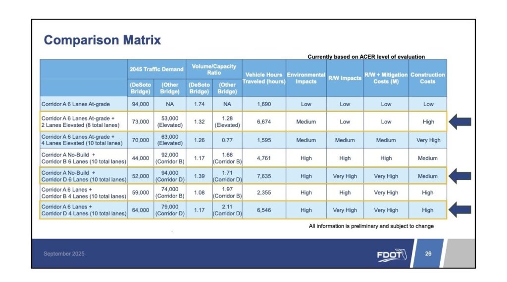
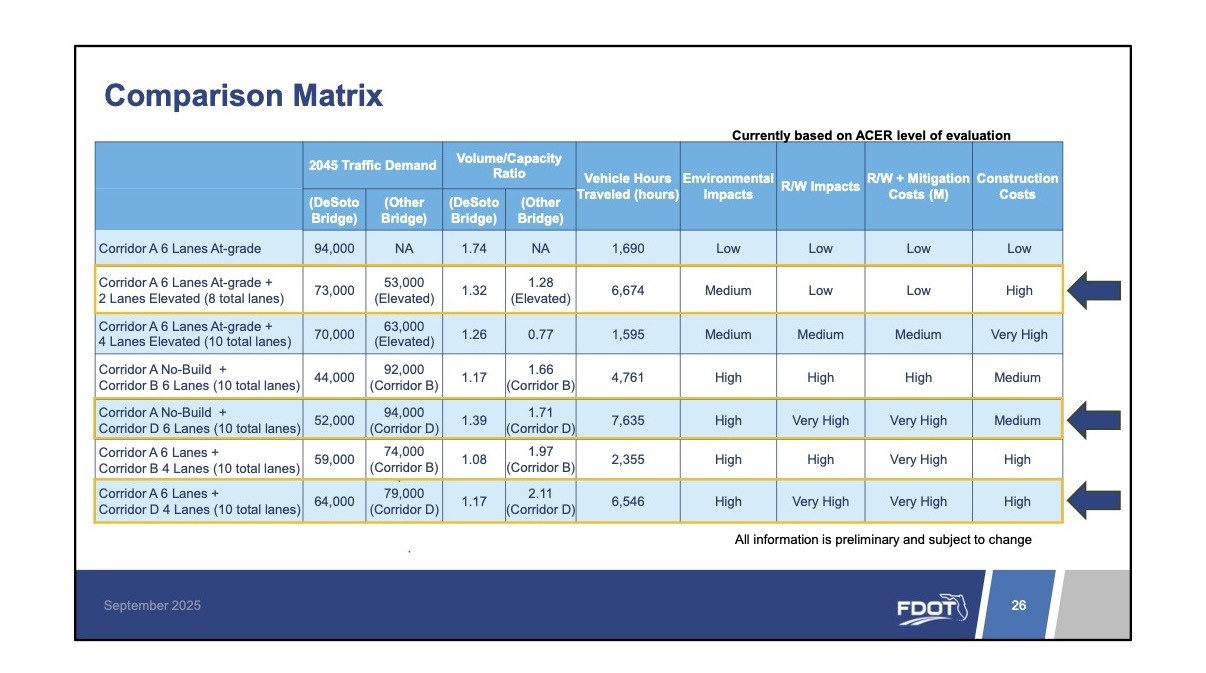
The DOT, in its Alternative Corridor Evaluation Study, looked at 10 Bradenton-Palmetto corridors and, at the conclusion, recommended three corridors for evaluation in its ongoing project, development and environment study:
• Corridor A, which begins at the State Road 70 and U.S. 301 intersection, travels along U,S. 41, ends between 33rd Street West and the U.S. 19/U.S 41 split. The corridor would utilize existing roadways and cross the DeSoto Bridge.
• Corridor B, which starts at SR 70 and follows U.S. 301 and Ninth Street East, includes a new bridge crossing over the Manatee River from Ninth Street East to 16th Avenue East, continues along 16th Avenue East, follows 29th Street East, and ends at the US 19/US 41 split.
• Corridor D, which starts at SR 70, follows U.S. 301, connects to 27th Street East via 38th Avenue East, includes a new bridge crossing over the river from 27th Street East to Leffingwell Avenue, continues along Leffingwell Avenue /36th Avenue East, follows Moccasin Wallow Road and ends at U.S. 41.
Now comes the work to develop conceptual plans for the corridors and evaluate safety, community, environmental and cost impacts.
Vilcé said, “Hopefully, as a community, we can all sit down and make the best decision as far as which corridor we might want to move forward.”
Corridors B and D perform well from a traffic perspective but have significant community impacts and opposition, according to the DOT.
And, for now, the focus is on Corridor A.
“The goal of FDOT is really to maximize our current infrastructure, which is Corridor A,” project manager Michelle Rutishauser said.
Three primary options for Corridor A are:
• Widening to six lanes throughout.
• Widening to eight lanes throughout.
• Widening to six lanes with two elevated lanes in the median.
For now, eyeing the options, the DOT says each option involves tradeoffs across community, environmental and cost considerations.
For Corridor A, widening beyond six lanes provides only a limited benefit while creating greater property and business impacts, with intersections remaining the key bottlenecks.
Elevated options, according to the DOT, could help separate local and regional traffic but are costly and require further study.
Did you know?
One key finding in an origin-destination study for the Bradenton-Palmetto Connector Project is that 47% of the traffic congestion in the study area is pass-through, meaning the drives begin and end outside of Bradenton’s downtown/riverfront area and north of Palmetto. The percentage is up from 31% in 2014.